FREQUENTLY ASKED QUESTIONS – SECTION RC3 PUBLIC MEETING Q&A
The following FAQ are transcriptions of the video recording from the question-and-answer portion of the virtual public meeting held on April 23, 2025.
Click here to view the FAQ from the comment forms received after the public meeting.
Click here to view the standard RC3 FAQ page.
The roundabout will fit in the footprint of the existing intersection. Additionally, there should be limited parking effects on Bellevue due to funerals thanks to the splitter islands. This is something we will look into further.
The property lines that are shown are just from the property mosaic that we have developed currently.
The top entrance to the parking lot from the service road is being maintained as well as the entrance from Park Avenue. There is only a little change currently projected, however this is still in the preliminary engineering phase, so there may be changes made yet.
You would get on US 1 Southbound and then immediately get off at the 413 interchange. Then, you would proceed straight through to Gillum Avenue and that would put you on Hill Avenue after three intersections. So, you would be back on your path without having to go into Langhorne Borough.
The project is still in the environmental clearance phase so we do not have a determination of actual right-of-way impacts, at this time, that we can state definitively.
We are currently evaluating right-of-way impacts, really at this stage we don’t look to closely at linework to adjacent properties, so we can’t really say one way or another at this time because we’re still working through the design. We’re not at that level of detail of design yet. We’re not anticipating any total takes in this area by any means though. But there is likely some minor strip takes along the four quadrants. The intersection itself is fairly large now so it did help accommodate a standard roundabout better than if it was a smaller intersection to begin with.
At this time Right-Of-Way impacts have not been determined, and we are still coordinating with PennDOT and with the municipalities with regards to which sections of the frontage road will be maintained and which will be turned potentially into a shared use path. We are still in preliminary engineering at this time, so some of these decisions are still being studied. This stretch is proposed to be maintained for that house because that’s the driveway, that’s accessing it from that portion of service road, but without going out of our way to take additional houses for no other reason that is not in our purview.
That traffic signal is beyond project limits. So, that would have to be a separate study on a separate project.
There was no detailed study done regarding property value impacts due to the construction; that is not typically part of an environmental assessment
Specific to East Highland Avenue, that is beyond the project limits, so it’s really not being looked at directly. That can be obviously passed along to PennDOT for them to look at if it is a part of their network of roadways.
We are not guaranteeing the same amount of traffic; there will be an increase. However, the increase is local residential traffic of people who live in the houses along those roads or in the adjacent houses in neighborhoods that stem off those roads is the anticipated increase in traffic. So it’s not necessarily new people that are going through those roads. It’s residents going home and coming from home.
The state does not restrict traffic onto state roads because it is the taxpayers’ right to use the roadway. The local municipalities are allowed to restrict truck size on their own roads.
We go based on DVRPC’s regional traffic model and that accounts for development that they know about, not just potentialities. We have coordinated directly with Woods School. PennDOT does not review local developer master plans; they only look at the traffic impact studies. PennDOT does look at any permit requests for driveways and so forth.
Most need to be replaced due to poor conditions. The West Interchange Road and Corn Crib Lane overpasses have piers or other factors that will conflict with the proposed US 1 improvement, such as removing the 16-foot-wide separation between the US 1 freeway and the service roads and necessitate their replacement. Additionally, all three of the overpasses do not meet vertical clearance requirements and have been struck by trucks in the past.
They will be in the technical files of the environmental assessment document that will be published later this year.
We used DVRPC’s growth rate, and they take into account development and other factors to determine that growth rate. The idea of that is to capture any development and any other factors that may increase trips in that area. We have reached out to the engineering firm for the developer to gather information on the potential impacts.
We are talking crashes holistically throughout the 2.5-mile corridor. I believe there have been 3 fatalities at least along Route 1 itself. It is not isolated where you have a fatality and you put in an interchange; the analysis does not work like that.
The reality is zero fatalities is FHWA’s goal, so we have to look at it more realistically and that means you can’t just cut pieces of the corridor out and put in an intersection. You have to look at the corridor as a whole. The safety analysis will be included in the technical files associated with the environmental assessment. So you’ll see all that backup data.
So we’re not talking many fatalities. There are quite a few crashes out there. When a crash occurs along Route 1, there is no room for maneuverability on the main line; so, it automatically incurs a roadway closure of at least a lane, possibly two lanes and that diverts traffic onto the frontage road. At that point you do get cut through traffic of people trying to get around the service roads, going out through the neighborhoods in that case.
The roadway will be wider, so you’ll have two travel lanes on mainline Route 1 in each direction. You’ll have five foot inside shoulders and 12-14 foot outside shoulders. That makes it easier to actually move traffic around an accident or even get traffic or disabled vehicles off the roadway onto the shoulder to maneuver around the crash site.
We have looked at this intersection and to install a traffic signal the intersection needs to meet warrants. It does not meet these requirements, so PennDOT is not allowed to install one.
One of the reasons we recounted in 2024 is to assess the traffic after the pandemic was over. It should be noted that we are applying a growth rate that is provided by DVRPC, so they do model projected growth. So, we do try to account for increases in traffic in that way.
We have had direct contact with the church and have their input regarding their needs. As currently designed, there is no impact to the AME church. We discussed the traffic increase on 413 is minimal and is just shifting traffic. We are currently working with the borough with regards to pedestrian access and traffic calming in the area of the AME church. The goal is to slow traffic and make it safer for pedestrians in that area and the adjacent library area too.
The short answer is yes, we are still in the environmental study phase and going through the environmental assessment process. This may cause us to reevaluate our plan if the environmental assessment dictates the direction we take. If there is a finding of no significant impact then we move to the final design. However, if there is a finding of significant impact then it could be reverted into an environmental impact statement and additional analysis would have to occur through the environmental impact process before continuing on beyond that.
We are working on transcribing the Q & A part of the meeting. The video is posted on the PennDOT website. Link: Spring 2025 Virtual Public Meeting – U.S. 1 Improvements Project.
We do not typically include railroad blockages in our traffic analysis. We usually just assess the conditions during the AM and PM peak hours. Additionally, 413 southbound should have no traffic increase, so the project should have no effect on its current condition.
That will be a part of the project technical file with the Environmental Assessment document and that will occur before final design.
Yes, there have been meetings with public officials recently and Last fall (2024) we met in person with Senator Farry and Representative Hogan at Senator Farry’s office with Langhorne Borough officials at the same time. Representative Hogan has had staff on several recent public officials calls, too. So Representative Hogan is aware of the project and we always keep Senator Farry involved in all our correspondence with Municipalities.
We did consult with the bicycle and pedestrian master plan for Bucks County and at the same time we did reach out to the bicycle coalition. They have not responded back to numerous attempts to reach out to them for their feedback.
We continue to coordinate with the municipalities with regards to the design, and we will continue to do so through the environmental assessment process. At this time, the current build alternative as shown is the main build alternative being carried through the environmental assessment document. And that’s the way the process works and in this case it’s either build or no build.
At the time in 2013, everyone received notification of the public meeting at the time. Additionally, there will be opportunities during the hearing for people to provide their input. There is still an opportunity such as we have here for people to provide public comment and reach out through the public comment forms and provide their input at this time. We continue to work with the municipalities; Middletown Township, Langhorne Manor and Langhorne Boroughs.
Middletown Township and Langhorne Manor have indicated to us their support of the project as it is currently designed, but we will continue to coordinate with all the municipalities as we move through the environmental assessment process.
That was just re-establishing the connection of North Street, so it does not end in a cul-de-sac or a dead end. With the removal of the service road down below North Street, adjacent to Route 1, that is just an extension of North Street to connect it to Hulmeville Road and maintain that connectivity from Myrtle Avenue to Hulmeville Road.
This goes back to the purpose and need, we are not attempting to alleviate traffic on Route 1. The goal is to facilitate safe and efficient travel on Route 1 along with system continuity. We are not directly diverting traffic from Route 1 onto any of the side roads according to our studies.
In a residential area construction is usually done during the daytime hours unless there is a specific reason, like if they would have to affect traffic overnight along Route 1 itself. The assumption is that the majority of the work will be done during daytime business hours.
The service roads fall under the jurisdiction of the appropriate municipality. Maintenance of the service roads are and will be the responsibility of the municipality. Cost for maintenance is borne by the municipality.
Again, we were talking specifically about the Level of Service based on the questions regarding the perceived increase of traffic along 413. The purpose of this project is to address safety on US 1. The levels of service discussions were ancillary based on the redistribution of traffic to two new interchanges.
We do not currently have the standalone cost out broken out for the noise walls because we are still in the study phase. Sound barrier costs vary by project depending on many aspects, so a clear answer is not available. Any of the costs associated with the sound walls are borne by the project’s sponsors, for example FHWA and PennDOT, not by property owners. It’s not necessarily the traffic increase that warrants the analysis, it’s the movement of traffic, the redistribution of traffic that triggers the analysis and then it’s strictly decibels if it’s over the 66 decibel threshold for residential or there’s the increased component if there is an increase of so many decibels then it triggers.
There’s also a function of the traffic volumes, the composition of the traffic, cars versus trucks, which can have an increase in the volume, as well as, the proposed distance from the noise sensitive receptor. At this time it’s difficult to identify specific volume increases that would generate traffic noise impacts.
Typically only properties directly affected by construction activities, whether it be permanent impacts to the property or temporary impacts to the property, are compensated as part of the right-of-way acquisition process. PennDOT does not compensate for indirect impacts to properties away from the project.
The public hearing that will accompany the advertisement and public review of the environmental assessment document is anticipated for either the end of 2025 or early 2026 depending on the final completion of the EA document and its eventual posting for review. We anticipate that to be a hybrid style meeting with an in-person component.
In our discussion with Our Lady of Grace Cemetery, they laid out what their typical procession is. which comes down from Gillam or Old Lincoln Highway down Hulmeville Road, down the existing service road to the front entrance on the US 1 side. That’s direct feedback that we had with them with the connection that they requested, coming from Gilliam or Old Lincoln Highway to Hulmeville Road, then onto the existing service road to the entrance of the cemetery.
As part of our traffic study, we also do a safety assessment. We do a comparison of the build and no build conditions. It is more focused on vehicular traffic, because traffic is not increasing just being redistributed, we are showing no increase in expected crashes.
Gillam Avenue was within the limits of the project study area so with any analysis that takes place, that will be included. Any noise, air quality analysis will be included as part of the EA document.
Highland Avenue is a part of the traffic study, and we added additional intersections to analyze those with our updated traffic study. It’s a similar situation to Gillam Ave where there is going to be an increase of traffic, but operationally it is still a low delay, and it’s local residential traffic.
Typically we do some assessments with the air quality monitoring, but it isn’t a typical component of a project level analysis. But there is air quality assessments that are underway as part of the project’s environmental documentation. Additional information regarding PennDOT’s project level air quality analysis can be found in their PennDOT Publication 321, which is available online.
To access Route 1 South, go to Highland Avenue and reach the new interchange at the south end. If heading north on Route 1, make your way to 413 and get on there. There is no traffic coming from Route 1 that would be cutting through the neighborhood, only the adjacent properties between Park Avenue and Fox Court that are coming up to that portion of the service road.
Fox Court and Fee Avenue are currently part of our traffic model. Jeffrey Lane included in the report due to them connecting directly to the frontage road. Jeffery Lane was not included due to it being adjacent to the frontage road and it does a loop around, so there is no real destination.
There is going to be an increase in traffic with a 29% increase in the peak morning hour of 7-8 AM and an increase of 17% at the peak afternoon hour of 4-5 PM. However, there is to be no real increase of delay when traveling through this section even with the additional traffic.
Some of the traffic being discussed that is currently on the service road, comes from Route 1 and that will no longer have access directly from Route 1, so a portion of that traffic will stay on Route 1 to get off at the southern interchange to access the southern portion of the project down around Neshaminy High School. The traffic increase would be local traffic; it would not be cut-through traffic.
This crosswalk’s location has not been finalized yet. We are still looking at multiple options with one being on the library’s side and a different option of where it is currently. We are looking at doing one side of the road with a crosswalk, not both sides. This is still being worked on in coordination with the borough. Additionally, we are looking to put another crosswalk at Richardson Avenue intersection north of the stated location. That is all being coordinated with Langhorne Borough directly.
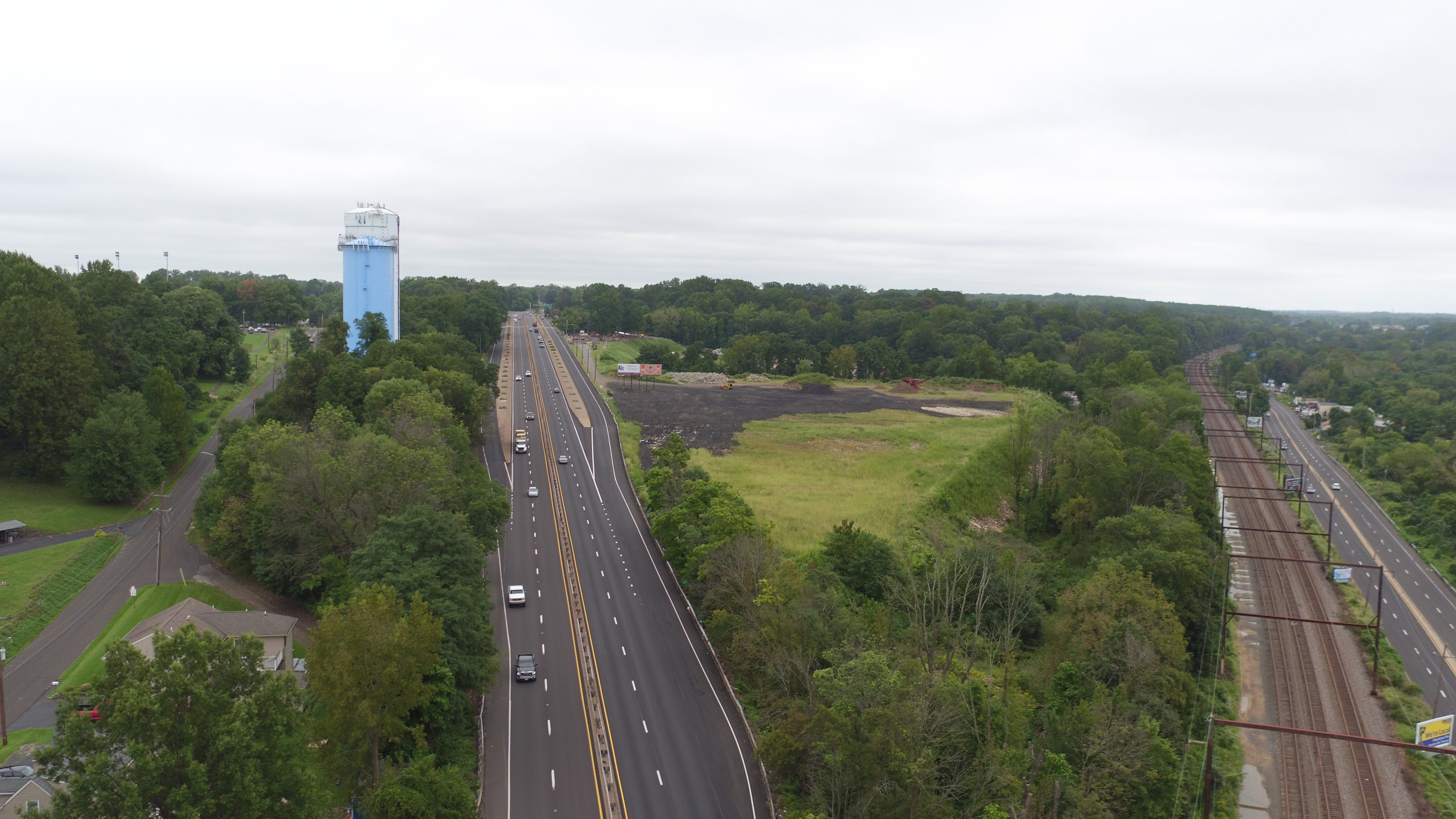
The starting point is just south of Neshaminy High School, and the end point is just north of the Corn Crib Road Overpass, which is roughly 2.5 miles of US 1 mainline.
We can take a look at that and review if it is a major concern. We can look at the traffic numbers and see that that is a major travel path for local traffic; we can take that into consideration. Maybe even re-establish the frontage road through that section. That would be in coordination with the municipality because it would get turned over to them to maintain.
Current anticipated start time for this would be starting at some point in 2027.
There is a predicted 29% increase in the morning peak hours of 7-8 AM and an increase of 17% at peak afternoon hours of 4-5 PM.
The purpose of this project is to address safety along US 1 through the frontage road corridor section. It was identified as an unsafe area through study; there are incidents of crashes and fatalities throughout. The needs being addressed are primarily safety along Route 1.
At this point, we have to treat this as a completely separate item. We can only deal with how traffic is currently and how it is projected to be. It’s difficult to account for things like SEPTA funding and threats to cut service because if they do not come to fruition then our design is correct, but that’s something that is unpredictable. We do coordinate with SEPTA on bus stop locations along 413 in particular for this project. With this coordination, we try to give them everything they need in the end.
On the PennDOT website.
It is still a hammerhead design; there is just a little different of an orientation to it because the connecting road is rotated near to a 90-degree angle.
We can show the color plot again, but the design is not finalized. Until the EA is approved the full scope and nature of the project is not final. Even after that sometimes we have to change, but definitely not before the EA we can project the impacts. With still waiting on the approval of the EA report, we cannot know the full scope and nature of the project due to many changes being possible.
There is extensive pedestrian and bicycle accommodations with this project. Many new sidewalk connections, ADA ramps provided, pavement markings for cross walks, and pedestrian signals. There are quite a bit of enhancements as far as pedestrian accommodations and safety. Within the limits of the project, we are accommodating pedestrians and bicycles to the extents possible.
Based on initial indications, the US 1 mainline bridge over Highland Avenue and the bridge carrying PA 413 Pine Street over US 1 will be staged construction.
The West Interchange Road bridge and the Corncrib Lane bridge will most likely be detours. With the lower volumes of traffic, the contractor can demolish them and then get them rebuilt a lot quicker than a staged construction. This is still under analysis.
As part of this project we are updating signal timings and coordinating the signals so that will help the cars stay together and hit green lights in succession to get the cars through more efficiently. Additionally, we will be extending the left turn lane north on 413 to 213 to help store some of the left turning vehicles for the additional queuing that is expected in the build condition.
When talking about the level of service that just means how much delay there is. The delay is expected to increase by one second, but the traffic at the intersection is not projected to increase more like the traffic is being redistributed. With slightly more traffic on 413 and slightly less on 213. Additionally, acceptable levels of service are defined in PennDOT publications, so that they are consistent across the state.
The previous construction from 2014, at the Maple Avenue/213 interchange, is not known to increase traffic. Any increase in traffic at that interchange is due to natural population growth and development. We do not see any additional major development coming into this area to create traffic generation beyond natural population growth.
Any potential development is included in our traffic numbers using DVRPC’s traffic volume model. So that takes into account any potential development increase in our traffic numbers. We are coordinating with DVRCP to get a verification that there have not been any additional changes to the traffic model since we last coordinated with them.
As far as PennDOT is aware on a state road we are not allowed to restrict traffic, but if there is a very specific roadway and the project that we can be informed of, we can always inquire farther about it. But again, PennDOT roadways are state-owned and every taxpayer has the right to use of the roads.
On 413 it is about a 10% increase in traffic at the PM peak. Almost all of it is northbound left turn onto 213. There will actually be a slight reduction on Maple that also occurs. The intersection will be balanced and the volume passing through the intersection will be essentially the same.
This is to be determined. We are actively working with the school district. They are aware of the project and have seen the project. But, at this time, since we are still in the environmental clearance process, I don’t think they’re really looking at any detail at effects on bus routes themselves.
Bus stops along the frontage road will be safter because there will be less high-speed traffic on the frontage roads. Any buses that were using the service road to get to the school will use US 1 and get off at the new interchange at the south end of the project.
To get onto US 1 Northbound from 413, you would come to the southern intersection with Woods Drive and either make a lefthand turn at the light if heading northbound on 413 or a right hand turn if heading southbound. That would be your ramp connection to get onto Rt 1 North.
The detailed abatement commitments will not be made until the final design phase of the project, so they will be analyzed through the preliminary design; but the decisions will not be made then and at that time the affected communities will be given the opportunity to provide feedback including support or opposition to potential sound walls. At the same time, the heights are based off of the abatement potential and acoustic profiles that are out there based on the proposed conditions.
Any sidewalk installed adjacent to the roadway is constructed by PennDOT at their expense gets turned over to the local municipality for maintenance responsibility. Typically, a municipality will then turn over maintenance responsibility to the adjacent property owner through the borough or municipal ordinances.
Any closures that the contractor would need to do construction in front of a commercial property, they will coordinate with the business owner at what the most convenient time for them to affect access to their property.
It is accounted for, but the frontage road traffic won’t be the same because the frontage road won’t be connected to US 1; So some of the traffic you see now will no longer be on the frontage roads they will be directed to one of the interchanges then it will be directed to most likely to the road they want to get to. Say at 413 to go to New Town they will be put onto 413 from US 1.
That will be posted in the fall as a technical report attached to the environmental assessment document.
As part of the EA document, we will provide the traffic and safety study. Included in that is the origin and destination study for the redistribution of traffic so you can see where it’s anticipated traffic will go or be redirected. We studied where people wanted to go when they left Route 1, and how many dwell in the local neighborhoods adjacent to Route 1. A fairly large number of people that are currently being redirected live adjacent to Route 1. It’s a fairly large proportion compared to pass through and cut through traffic.
The preliminary design sound wall evaluation is currently under development as part of the environmental clearance process, the results of which we will publish as a part of the EA document when that is finalized. Even at that point, abatement consideration is still considered preliminary, and no commitments are made until we get to the final design portion of the project. Once the impacts have been identified in the corridor, the detailed abatement recommendations are still pending at that point.
Sound walls are not designed or intended to provide safety improvements. Decisions regarding sound walls will be based upon the Federal Highway and PennDOT’s warranted, feasible and reasonable process as outlined in their PennDOT publication 24.
Sound walls in a corridor are typically protected by a single face concrete barrier in front of them to keep people from hitting the noise wall. That by default becomes a safety measure with having a concrete barrier in front of the noise wall to keep traffic from hitting the wall or leaving the highway.
PennDOT and the design team worked and coordinated with Langhorne Borough’s traffic/safety engineer at the time. We reviewed their analysis and a lot of what they were suggesting actually did not meet what the project purpose and need was. It did not do what they were claiming it would do.
Information that we collect from the air quality assessment and noise assessment will be incorporated into the environmental assessment document including the environmental clearance process. That information is a summary of some of the technical analysis we do. That information will be made public during the draft EA assessment, and the project technical documents will be made available as well. We will be looking for comments primarily on the summary information that will come out as part of the EA document.
The information will be made available in a variety of ways. It will be in person at the PennDOT District 6 offices. It will be made available at various public locations throughout the multiple boroughs and townships at their offices. It will be made available online on the website and often times at a public library. We work to make sure that it is accessible to all individuals in as easy a way as possible.
We did include that as part of our traffic study with the updated data that we collected, we assessed more intersections along Gilliam and as part of that we also do safety analysis to attempt to predict crash information. That isn’t specific to pedestrians that’s for vehicular traffic but we do assess that.
This is being discussed with the municipalities and the public officials. The potential loop we have looked at provides various connections whether it’s in areas where service roads are removed and it is a standalone shared use path. If it’s in conjunction with a stretch of service road that needs to be maintained and those would be accommodated on the shoulder. The stretches up at the north end where it would be able to use existing sidewalk that’s currently out there.
So not that it’s going to be a continuous shared-use path for the entire stretch but multiple forms of connections that create the full 4-mile loop that runs down from Highland Avenue at the south end and loop up along those existing service roads up to the 413 Pine Street connections with the proposed sidewalk that we have up there.
We are still in the initial stages as far as gathering feedback and was just an idea, bikes and pedestrians and multimodal is a hot topic these days and trying to provide some of those additional connections to the local communities is something we were putting out there as an option to discuss with the municipalities. Not that it is set in stone, and it could happen for the entirety or could be one or none of the municipalities.
Further studies have not been put out to date to get any sort of commitments from the municipalities affected by it. We have referenced the Bucks County Bicycle and Pedestrian master plan that was previously created just to look at some concepts where previous surveys had indicated potentials for bike paths. We are using other references and studies as a basis for the concept.
We have had direct coordination with Neshaminy High School, it’s been a few years since contact, but we will reengage with them soon. We have made adjustments to some of the design per the request due to those large gatherings.
Regarding the Fairhill Avenue, Highland Avenue and Old Lincoln Highway intersection, leaving it signalized so that it can control the traffic signal itself. The roundabout itself is not an impediment to traffic flow especially if it’s heavy in one direction, so that should not have any negative effect on the traffic flow of a large event coming out of the school.
The video of this meeting will be posted on the PennDOT website. Along with PDFs of the slides.
At the end of the day, the intention was to look at bike and pedestrian mobility within the service roads and look at opportunities where we could remove the service roads because the service roads themselves are maintained by the local municipalities and not PennDOT.
Obviously as long as the frontage or the service roads are detached from US 1 they can be retained, but they will not have access to US 1. At that point they would just be local one-way connector roads between say Bellevue and the Southern Limit of the project on either side.
At this stage of the project we have not looked at right-of-way impacts in detail.
Native American tribal consultation will be conducted as part of the project. It is going to be completed by a combination of PennDOT and the Federal Highway Administration. This is an ongoing process as part of the environmental clearance.
From a safety standpoint, there have been multiple fatalities along the corridor for mainline Route 1 traffic. There are no shoulders, so there is no recovery for errant vehicles if somebody has an issue. There is nowhere to pull off if you have a breakdown. The raised concrete traffic islands do not prevent vehicles from leaving the highway and there have been incidents of vehicles leaving the highway, crossing the raised concrete traffic islands, and ending up either in somebody’s front yard or in another accident along the service roads themselves.
The reality is to improve it we need to provide more room for maneuverability along the mainline travel lanes so that requires an inside shoulder and a more substantial outside shoulder for vehicles refuge and concrete barriers to prevent errant vehicles from leaving the highway. Also, the West Interchange Road overpass has concrete piers in the traffic island that are a hazard and are of concern.
The study for this project started back in 2011, and the initial project design was to eliminate the raised concrete traffic islands, to eliminate the intermediate crossovers because those were where the high rates of crashes occur or have a tendency to occur and still leave the access/service roads open at the northern and southern limits.
We presented this to the public and got extensive push back on that option. We had a public plans display and then Senator Ferry led a town hall back in 2014 regarding this. So, at that point PennDOT made the decision to advance the southern two projects RC1 and RC2 and reconsider the RC3 corridor and look at alternatives. The primary alternative being looking at interchanges and closing the frontage road because of the concerns from the initial public involvement.
With the delay only increasing by one second, I don’t think that it will encourage people to take local roads. If the delay between the build and no-build was greater, that would be possible, but anyone that would do that in the build condition would already be doing that.
This would operate as any standard limited access highway. It would operate like the limited access sections north and south of this area as far as emergency vehicle access. If need be, there could be discussion about intermediate access gates, but that would be a further discussion with the emergency management services.
That service road would be able to be removed north of Fox Court and otherwise hammer head cul-de-sacs would be provided for some of those additional side road termini, such as at Fee Avenue. From a traffic standpoint all the traffic that would be using that retained section of service road approaching Fox Court would all be local traffic.
Residential traffic that dwell or reside in the local areas is the anticipation it would be very limited like through-put traffic (as) it would be very inconvenient; it wouldn’t make any sense to use as a cut through. It would only be the dozen or so houses that are along the service road North of Park Avenue and then on Timber Lane itself that would otherwise be coming into Fox Court that don’t reside within that area in the first place.
Our analysis is showing that as far as additional traffic at 413 we are showing additional left turns from Pine Street onto Maple (Avenue). It should be noted that a lot of this redistributed traffic was coming to this intersection from Maple (Avenue), so most of the new traffic on 413 was already coming into the borough through 213.
We are also looking at extending that northbound left (lane) further south down to Richardson since it’s currently just a painted median in the first place to provide more left turn room and adding left turn signals. Currently the intersection is projected, if we wouldn’t build the project, to be a 31 second delay per car and with the project it would be 32 seconds in the PM. When I was saying there is no real difference, it’s really a one (1) second difference between the build and the no-build condition.
There would be a single face barrier to provide a substantial barrier plus the shared use path is essentially just a side path. There are different terms used to talk about very similar situations. With the location of the trail being detached from the roadway it would be considered a shared use path in this situation. There is a grass buffer as well, so they are not right behind the barrier. The shared-use path can function as any type of trail accommodating bikes, pedestrians, and other non-motorized vehicles.
If the question is with regards to removing the proposed interchange or not having any interchange in the Pine Street / Bellevue area and pushing all the traffic to Maple Avenue, that wasn’t directly looked at. The reality is 213 interchange and 213 itself heading into the borough is heavily traveled so pushing all the traffic from the 413 Bellevue Area to Maple Avenue would only make Maple Avenue interchange by itself worse because you are taking two options and consolidating it into one interchange.
This would only worsen traffic. It’s better to have them split and balanced and make improvements with 413 and all the traffic stays the same, it’s just whether they go 213 or 413. The previous project limit did stay out of the historic district but with input from Langhorne Borough and their additional items they wanted the project to address, we did in collaboration with Langhorne Borough; at their request, we extended the project limits to go into the historic district. This was done to address traffic calming concerns and pedestrian access concerns between Flowers Avenue and 213.
From a safety perspective and the operational perspective with the traffic analysis it was determined that a roundabout would be the preferred solution at this intersection, as opposed to a traffic signal or a stop-controlled intersection.
Air quality analysis is part of our preliminary environmental engineering clearance and is currently being assessed in the context of the proposed improvements. Results will be included as part of the environmental assessment report being prepared for the project and we are also currently assessing some adjustments based on actions by the current administration in the Federal government in terms of how they are proposing for greenhouse gasses and other emissions to be reviewed so we are currently working with PennDOT and Federal Highway Administration to assess those changes as they come about.
This project itself, we have looked for all points, is not a traffic generator itself. All we are looking at is the current traffic and future traffic projections regarding the development of the area. It does not see any traffic generating nature within this project. We are not creating any business or anything like that out of this project to actually contribute to any increase in traffic.
The project noise assessment is being performed in accordance with Federal Highway and PennDOT guidelines. Which are outlined in PennDOT’s publication 24, which is a publicly available document online. The design year build conditions around levels determine impacts and vary by land use, so for example residential impacts thresholds typically occur around 66 decibels.
Impacted land use warrant abatement consideration, typically provided in the form of sound walls. Warranted abatement options are then assessed for feasibility, which is constructability and reasonableness which evaluates cost effectiveness and the performance of any proposed barriers or noise barriers in that case.
In round numbers it’s approximately $150 million, but there are a lot of caveats and contingency built into that number. That could change due to construction starting in 2029 due to inflation, changes in design, and cost of materials at the time. There are a lot of factors that go into that.
At this time actual right-of-way impacts are still being determined because until we get environmental clearance nothing is guaranteed. After that, if we did get a finding of no significant impact and we start the right-of-way acquisition it would go through the normal process. Once it has been determined that a property is going to have acquisition on it, the right-of-way team would reach out to the property owner. Each property will get their own individual drawing showing what impacts they had. You would then be able to get an offer from PennDOT which would tell you how much they are willing to pay and then you can negotiate with PennDOT on that. There is a lot of stuff that goes into that for coverage where PennDOT pays for independent appraisals and covers a lot of the costs for the property owner during the negotiation process too.
Please note that the Frequently Asked Questions (FAQs) that are on the project website. One of the questions does talk about what happens if PennDOT needs my property for the project. Listed under that question is a brochure that talks about the right-of-way acquisition process for property owners.
If your property is impacted, you will be contacted by the PennDOT acquisition team and PennDOT’s acquisition team will listen to all of your issues and involve the engineering team during that negotiation process, to make sure that the best solution is put in place for any impacted property owners.
For the cemetery specifically, the frontage road from Parkvale south would be converted to a two-lane driveway. That will get them in and out and that is the way we were told that their precessions prefer to go and that is the front entrance or the frontage for the cemetery. They do additionally have the back entrance off of Old Lincoln Highway, so they will still have access to it.
Regarding the Sinclair station, we will be maintaining the section of frontage road between Bellevue (Avenue) and the station to allow for access off of there and to Bellevue (Avenue) but to actually get from Route 1 to the gas station you would have to take the interchange like you would at any normal limited access highway, get off the interchange, and proceed to the gas station.
We have done some preliminary studies regarding traffic control through the corridor. It won’t necessarily be sequential from south to north, nor will it be done all at once.
There will be certain sections that are easier to work on because we do have to maintain two lanes of US 1 traffic through the corridor at all times, during high traffic times, peak hour times and sometimes during the daytime hours too.
So, it will be a little more patchwork. We will do it in as big of sections as possible to be convenient and more efficient for the contractor, but it won’t be all at the same time nor will it be sectioned south to north or north to south.
Our updated traffic analysis shows the same level of service for the build and no build conditions. Basically, prep-analysis has levels of service A through F with A being the best and F being the worst. Our level of service for both the build and no build condition at Pine (Street) and Maple (Avenue) is level of service C.
So, we are not projecting that the signal will get much worse and as far as the new signals we are projecting that both of them will be level of service B. Which is a very good level of service.
Our traffic analysis shows that they will operate well. It should be noted that with the two new signals they will be coordinated to work together so that ideally when someone gets a green at one as they continue through, they will hit the next green and that will pull two in together and operate better that way.
That is a traffic calming feature in itself as opposed to coming up to a stop sign. As I mentioned, there’s increased safety benefits with roundabouts versus stop control or signal control. Due to the low volume roadways that are here, traffic analysis and models have shown that the mini roundabout functions very well. It helps slow down traffic but keep it flowing as they traverse around / are directed around the central island.
The benefit is that it fits within primarily the existing footprint of a smaller intersection such as this so limits any adjacent property impacts to be minimal. But then also still maintains truck turning movements if a bigger truck does need to turn through the intersection since it would be a smaller intersection. They could traverse that center island. All those islands would be raised with truck apron curb. So, it’s mountable but not desirable for the passenger vehicle to come flying through here by any means.
In this particular example, you can see the proposed typical section coming north here is eleven-foot travel lanes with a three foot outside shoulder. Multiple option were being looked at and discussed with Langhorne Borough.
This option looked at closing the northbound left turn lane in order to provide a mountable median, which would also double count as a pedestrian refuge so they would only have to cross one lane of traffic at a time. So it is narrower in the first place as you come up here compared to what it is today. In addition, fresh crosswalk marking, the rectangular rapid flashing beacon and increased pedestrian signing and there are solar panels and lights associated with that that would be triggered to get traffics attention whenever someone is crossing the road.
Other options would be not doing the median, like we’re showing here, but maintaining the left turn lane and then still maintaining a crosswalk with the rapid flashing beacon. We are looking at potential bulb-outs which would potentially narrow up those shoulders from three (3) foot to just one (1) foot right at the intersection. But heading north of Flowers Avenue it’s already one (1) foot shoulders so you’d only be able to do the bulb-out on the southern side of the intersection.
There’ve been various options that we are looking at that combine some of those different aspects to the traffic calming.
That was addressed through our origin-destination study, we analyzed additional intersections as part of our updated traffic analysis. There will be additional local traffic on Gillam (Avenue), but we are not finding that it’s causing increased delays because it’s not high (significant) enough to warrant that.
1) Maple Avenue interchange with US 1 will remain as it currently is. That was reconstructed in 2014 and will remain open also. We are just connecting that with an auxiliary lane which just essentially means it will be a weave lane between the 213 interchange and the 413 off ramp interchange. So, you would still enter Route 1 from 213, Maple Ave.
2) 2029 is the current anticipated construction start with a 3-year construction duration which would end in 2031.
This was a design decision from PennDOT at this point, based on the driveways that need to be maintained north of Park Avenue and maintain access for them as well as Timber Lane.
Once you get north of Fox Court, there is no property access onto the service road heading north, so there is no reason to continue the service road north of Fox Court at that point and otherwise connect it to that neighborhood network.
The roundabout itself has traffic calming effects with reduced speeds and whatnot, for people to traverse the roundabout in the first place especially with this being a standard roundabout at this location. No additional measures are currently being looked at beyond what is shown on the plan at this point.
Everything on West Highland Avenue heading west is all stop-controlled intersections and that is done by Langhorne Manor borough at this point too. Within the confines of the project limits, we are doing as much as we can to slow and calm down traffic heading onto West Highland Avenue.
That was part of our origin destination study to determine where cars are coming from and going to, and we found that the traffic impact is minimal; all the traffic will be filtering through to 413 and getting on the ramps there. All the traffic that was local traffic will obviously still be going through the local network to get to Route 1. Our analysis still shows acceptable levels of service and delay, and no major increases at any of the intersections in the network.
Based on our current level of progress with the environmental assessment, we will continue to develop the EA (Environmental Assessment) document through the summer and publish it this fall. We anticipate an environmental decision next summer of 2026 which at that time, assuming it’s a finding of no significant impact, we would shift into the final design / right-of-way acquisition phase of the project.
We anticipate that to start early in 2027. We anticipate that to take 18 to 24 months, which would put us in 2029 for a construction start. That’s based on where we are currently at. The construction would be anticipated to take 3 construction seasons or 3 years. We really have not gotten into detail on the construction schedule yet, but we are anticipating 3 construction seasons or 3 years.
There is one roundabout at the southern end of 413 with west Highland Avenue, Bellevue Avenue and Pine Street, the flashing signal, and then the mini roundabout on the other side that’s proposed at Gillam Avenue and Bellevue Avenue.
Those are the two at cloverleaf. Then the other one is the third one at the south end with the north bound ramp connections for Highland Avenue and the northbound ramps for Route 1.
There was a speed study done previously with the RC 1 and RC 2 projects up through RC 3 and based on that analysis it was determined to keep the speed limit at 55 MPH through this section. So, it will not be reduced but a section will open up to make it a little bit safer and more recoverable and more area for vehicles to move off the road, but the speed will not be reduced because it is 55 MPH south of there and 55 MPH north of there.
The bridges will all be replaced as currently scoped, and the four bridges being replaced are US 1 over Highland Avenue, which is the only mainline Route 1 bridge. Then, the West Interchange Road overpass over US 1 will be replaced.
The bridge carrying PA 413 or Pine Street over Route 1 US 1, will be replaced. And then at the northern end Corncrib Lane Overpass, which is also known as Devot Drive for Woods School, will be replaced also.
Additionally, there is the reinforced concrete culvert that was discussed that is also being looked at to be replaced.
There is a portion there that we kind of touched on earlier (part of the access road North of Hulmeville Avenue to Hill Avenue) that would remain. But the other portion north of Hill Avenue to Station Avenue will be able to be removed and converted to green space or a shared use trail that we were looking at.
Where a service road is to remain in place, that would be barrier separated with median barrier from the main line shoulder. If it’s to be removed and converted to green space we would be able to put in guide rail along that edge of shoulder instead of barrier, but obviously nothing is getting closer to the lawns as they are today, so that existing service road pavement footprint will just be converted to lawn.
Yes, Route 1 will remain a four-lane divided highway, limited access highway, as it currently is today.
Our traffic study does begin starting from South on 413 at the Bellevue intersection, and it continues north on Pine Street up to Winchester Avenue. It doesn’t go all the way up to Saint Mary’s, I believe they are referencing Saint Mary’s Medical Center, that’s north of where our project will be affecting traffic patterns, so we didn’t go up quite that far. Then at 213 it goes from Old Lincoln Highway to South Flowers Mill Road.
We have had meetings with Our Lady of Grace Cemetery regarding access to their property. They consider the frontage along US 1 as the main entrance, and we were told by them that their funeral procession uses the frontage road as it currently is and comes down from 413 to the cemetery entrance and that is the access they prefer to use.
The access off of Old Lincoln Highway they consider their back entrance. The portion from T-336, Parkvale Avenue, to the cemetery entrance will end up being converted to a two-way driveway for the cemetery, so that they can maintain their processionals as they currently are. Again, that was based on coordination with the cemetery directly.
At this time, we are still evaluating the impacts from the project and whether those would require/warrant a noise wall along the corridor, so some of that information is still being analyzed. At this point, we will have more details to come as the project continues further through the environmental analysis process, so at this time we do not know if that will be the case.